Mount Richardson was the first mountain we wanted to summit on our trip to Hidden Lake.
There are three summits (Mount Richardson, Pika Peak and Ptarmigan Peak) with scramble routes that form a rough semi-circle around the lake. We decided that if we climbed all three, we would feel it was a highly successful trip.
The night before our Mount Richardson ascent, we were thinking that we might continue from the summit over the top and down the col on the other side towards Pika Peak.
We could then summit Pika and get two summits in one day. We had read about people climbing all three of these mountains in one big push. That seemed like a lot but we wanted to leave our options open. Starting with Mount Richardson would allow us to continue to the next mountain and keep going until we got too tired or it got too dark to continue.
Beta:
- This route can be out and back or you can continue down the col toward Pika Peak. It is then possible to continue to Ptarmigan Peak and summit all three.
- We started at the Hidden Lake campground. I created a post with information about permits, reservations and getting to the campground. Read about it here: Hidden Lake Campground: Planning, Permits, and Hike In
- Elevation gain: about 800 meters from Hidden Lake
- Difficulty: Steep hiking on rock, scree and talus. We scrambled up some small steps but it looked like you could hike around them for a longer but easier route.
- Gear: I had gaiters to keep scree out of my boots. We brought helmets but didn’t use them. There wasn’t any overhead hazard.
Permit Required
A National Park Pass is needed to park at the trailhead. A permit is needed to camp. See the link to my post about obtaining a camping permit in the bullet point above.
Helpful Apps
- AllTrails: “Hidden Lake Campground – Mount Richardson”
- FATMAP
Websites
- Bob Spirko – Mount Richardson – He hiked in from the road and summitted in one day.
- Steven Song – Mount Richardson – He climbed all three peaks – PIka, Richardson and Ptarmigan – in one long day from the road!
Books
- Scrambles In the Canadian Rockies by Alan Kane
Trip Report
From the campground, we hiked to Hidden Lake. There is a good trail with a bridged creek crossing. Once at the lake, we turned left to follow the lakeshore around to green meadows.
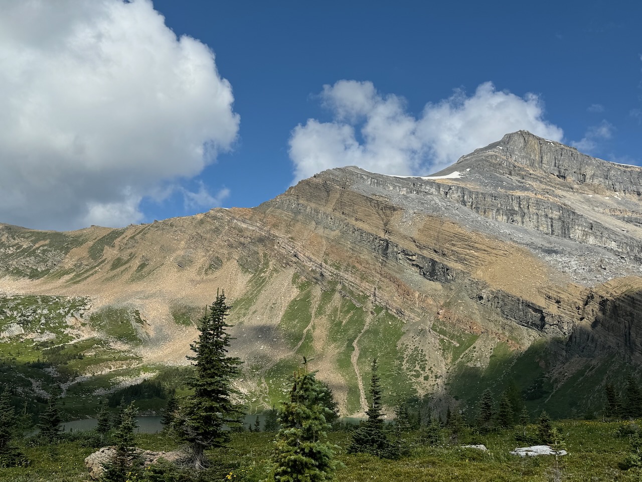
The black arrows on the photo below show roughly the route to the summit. There is a trail up from the lake through the meadows and through a talus field. The trail is faint but occassional cairns help to find it.
Then the route goes up the steep slope to gain the ridge. Once on the ridge, a good trail drops down on the left side and traverses scree and talus below the ridge top. It gains a small plateau with a snow patch just visible in the photo. Above the snow patch, multiple trails climb steep scree and rubble to reach the summit ridge. From there it is an easy hike to the summit. Details and photos of the route are below.


Here looking back at Hidden Lake as we start up towards Richardson’s south ridge.
Skies are looking a bit threatening but we are hopeful it will burn off.
Dan hikes up the steep slope heading to the ridge.


We decided to scramble up this easy rock step. We could have bypassed it on the left (out of sight) but we decided to take a more direct route.
This is another step we decided to just scramble up rather than hike around.


He is nearing the top of the ridge.
Looking up the ridge toward the summit. It is shrouded in clouds.
The trail runs across the slope below the ridge top to the cliff bands in the distance. There it goes above the cliffs on the right side into the clouds.


Further along the ridge, the trail is visible in the foreground.
Now nearing the cliff band where the trail pops up onto the ridge.
It heads up the far slope into the clouds.


We are almost at the far slope, trying to see our route to the summit. We intend to hike up into the clouds.
Here up on the ridge top, looking up the final slope before the summit ridge.
There is a small cliff band above.


Looking back across the valley we can see the tops of chairlifts at the Lake Louise Ski Resort.
Looking up our ridge toward the summit, we can see that the trail will easily pass through the small cliff band.
We will stay left of the big rocky bulges above on the right.


As we look back at the ridge we just came up, we see the clouds move in quickly to cover our descent route.
It was a bit eerie to see the clouds closing in on us.
Passing on the left side of the rocky buldges.


Finally up on the flatter, summit ridge. There is a snow field and, as we saw later, a glacier.
Through the mist we see a mound on the ridge in the distance.


It is a rather large summit cairn.
We made it to the top but the clouds obscure the landscape around us. No views. We are inside the pingpong ball.
There is a structure near the summit. We head over to investigate.


Underneath it, a medallion is set in the rock.
Geodetic Survey of Canada – Triangulation Station. Interesting. I have no idea what that means.

At this point, we know it is better to head back down the way we came rather than try to find our way down the col to Pika Peak. The clouds were so dense there was no way of knowing where to start descending. We decided to return to camp to get warm and dry out.

I start the descent, hiking by the snow field. I wonder if this is the top of the glacier.
As we hike down, it starts snowing and I am strangely delighted to get snowed on in August.
This is a photo we took a couple of days later from Pika Peak, looking at the top of Richardson from the other side.
The top of the highest snow field is where I was standing in the previous photo.
Seeing the glacier and the steepness of the route down onto the col, I was glad we didn’t attempt it in the thick clouds.


As we descended, the snow turned to sleet and then to rain. By the time we got back to camp, we were soaked, despite our rain gear.
We returned to the Halfway Hut near camp to dry out (seen here under sunny skies the day before).
There is a cute story about this Hut posted on the door.
Unfortunately, we did not get to meet the ghosts.

Despite the bad weather, we felt this first day of our trip was very successful. As we played cards in the Hut, we decided that the next day, we would head up Ptarmigan Peak. Then on our last day, we would try for Redoubt Mountain on our way back to the road. We would save Pika Peak for another trip.
If you would like to be notified when I publish my next trip report, please subscribe.

Reach the peak!
Read about our other summits: