On February 11, 2025, Dan and I skied Tryst Lake Chutes. We enjoyed it so much, I know we’ll go back and ski there again. It was a really great day.
What made it so great? Have you ever had one of those days when you’re hit with some big challenges and you push yourself to give everything you can to meet those challenges? And you end up surprising yourself with what you’re actually capable of? That was my day at Tryst Lake Chutes.
It was very cold, minus 25, when we left the van. In the past, I would not have ventured out when it’s that cold. But with proper layering, frequent eating and not stopping for too long, I actually managed to stay warm all day.
The uptrack included a lot of switchbacks, some quite steep. In the past, I often struggled to get around these switchbacks and I ended up sliding backwards. Then I’d blame my skins for not sticking to the snow. But this time, I decided to look at each switchback as a puzzle to solve. I chose good places for my skis, focused on shifting my weight, and used my ski poles to pull myself up when I needed an extra boost. It actually became fun.
The chute we skied was very steep, especially at the top. I was reminded of some of the double black diamond runs at Lake Louise. In the past, I would have been very intimidated by the steepness. I might even have turned around and tried to ski down the uptrack! But this day, I knew I had the techniques and ability to get down safely. And when I realized that making turns on that steep terrain was easier than I thought, it turned out to be a lot of fun.
Everything went smoothly and it was very satisfying. It was the first time I’ve felt like I can survive and even have fun on serious backcountry terrain.
The Beta:
This is a map of our route I recorded on Gaia GPS. It is the bright red line.

The yellow line is Smith Dorrien / Spray Lakes Trail. We parked at the side of the road and started skinning from there.
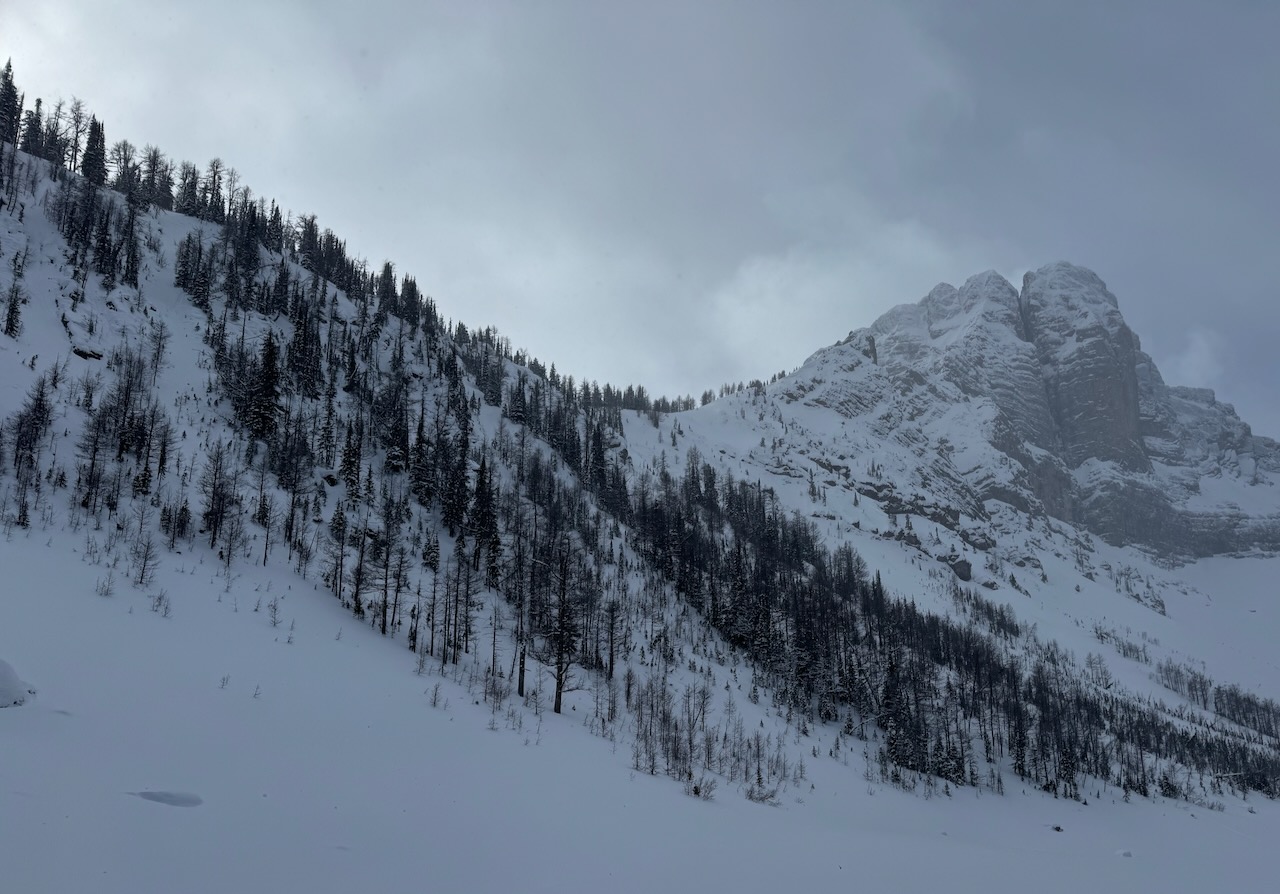
The photo below shows the view from the road looking towards the approach. The rocky mountain top above the highest black arrow is called The Fist. Tryst Lake is below the right side of The Fist. The black arrows point out roughly where the approach goes to get on top of the ridge above the lake.

The route starts by crossing the meadow at the bottom of the valley. There is usually a well defined skin track here, visible from the road.
The track goes into the trees and then branches out. The trail to Tryst Lake goes right and skirts around the bottom of the hillside until it comes to a drainage. Here it leaves the main trail and goes left up the drainage.
Eventually, the uptrack splits and the left branch goes up onto the ridge while the right continues up the drainage to the lake. We took the left branch and ended up climbing steeply to the top of the ridge above the lake. From there, we chose the best chute to ski down to the lake.
Trip Report

This photo is looking back at the road after we had skinned across the meadow and entered the trees.
When the trail branched, we went right. The drainage from the lake comes down behind the treed ridge in the middle of the photo. It comes out on the right side.
The Fist is barely visible at the back behind the treed ridge.


The trail contouring around the base of the treed ridge is wide, like an old road.
The treed ridge is on our left side in the photo.
Here the trail to Tryst Lake leaves the main, old-road trail. It goes down to the left to find the drainage.

Here the trail got narrower as it wound through trees.


Further up the drainage, it opens up a bit.
We made good progress gaining elevation toward the lake.
Eventually, we found an uptrack heading up to the left. There were many tracks ahead where skiers had come down. We came down that way at the end of the day. We went left up the hillside to gain the ridge top.

The trail went up steeply to the top of the ridge. Then it climbed toward The Fist.
Many switchbacks, some much steeper than the one in the photo, challenged my kick-turn skills.
This is where I considered each turn as a puzzle to be solved and worked hard to position my skis and use my poles to get up and around the turn as efficiently as possible.


Many switchbacks later, the trail flattened out. I believe we were at the top of the first treed ridge and heading to the second ridge which ran up to the base of The Fist.
The trail then dropped down to cross a drainage and went steeply up the other side.
Here looking back at the trail we have come up. We are heading toward The Fist high above Tryst Lake.

Figuring out Where to Ski

Here, from the trail, we look down on the lake.
This is the first chute we found. It is a steep drop off. I felt it would be too narrow for me to make any turns. I was hoping there would be other, more reasonable chutes or I would be skiing down the uptrack.
Across the lake on a high point on Tent Ridge, we see a structure we assume is a weather station.
As we proceeded along the top of the ridge, The Fist rose up at the end of the trail.
It was so magnificent, rising steeply from the top of the ridge, I vowed to come back in the summer and climb it.
As we traversed, we looked down each chute we came to. I joked that we were “shopping” for the best line.


We settled on this one.
Very steep at the top and narrow, I went back and forth sideways. Dan opted for jump turns.
Here, I am looking up from about half way down. I was able to get some nice turns once I was below the cliffs.
Looking down from the same spot, Dan is just below and Tryst Lake is far below.
What a run!

The photo below is looking up at the slope we skied from closer to the lake. If you zoom in to the slope on the right side of the photo, you can see where a small sluff avalanche has come down. The avalanche forecast was Mod/Low/Low the day we skied. I wouldn’t want to ski here if it was any higher.

Descent to the Highway

We decided not to go back up for another run and started across the lake, heading back toward the highway.
This photo is looking back at The Fist and the run we skied.
From the lake, we looked up at the chutes. Many options here but all steep. No green runs.


From the end of the lake, we took a track through the woods and found the drainage.
We skied down, eventually rejoining our uptrack where it left the drainage to go up onto the ridge.
The meadow at the bottom of the valley that we skied across to start the day is visible in the distance. The road is on the other side of the meadow.
We were able to ski all the way down the drainage to the main, old-road trail. There we put our skins back on and returned to the road.
This was such a great experience, I can’t wait to go back and ski there again.

Leave a Reply