We spent two days, January 12 and 14, 2025, ice climbing on Orient Point, a mountain in the Ghost River Wilderness Area north of Canmore and west of Cochrane. The first day, we enjoyed finding and exploring the climbing area. But we left with some unanswered questions, some mysteries from our first day of climbing so we went back for a second day to investigate further.
There is a different kind of energy in the Ghost. I don’t know how to explain it. Maybe it’s a feeling in the air. I felt it the first time I went there which was with mountain guide Jean from Yamnuska. It was summer and we climbed the classic multi-pitch Bonanza.
I’ve felt it everytime I’ve been back. It’s something unique to the area. This is a special place, removed from the stress and busy-ness of the world. I feel calm and peaceful there and at the same time, ready for a challenge.
Dan’s first ice multi-pitch, led by our favourite mountain guide Jean, was Anorexia in the Ghost. That was my second time climbing Anorexia with Jean. This year we finally felt ready to climb there on our own, without a guide, but we wanted to try something easier.
We chose The Joker, a WI3. We saw photos of it on Facebook and it looked really fun. Based on our pre-climb research, we were expecting to climb about 130 meters of WI2 approach ice on our way to The Joker.
However, we ended up climbing about 50 meters of WI3 followed by about 40 meters of WI2. The WI3 section felt even steeper because, unlike the popular climbs we had been doing in Kananaskis, this had not been climbed a lot and there were very few pick holes and foot placements. There was a lot of smooth, clean ice.
This WI3 climbing was enough for us on our first day in the Ghost on our own. I’m not sure what we climbed but it was definitely “Not The Joker”.
Beta:
- about 90 meters of ice on the left side of the apron below The Joker, about 50 meters of WI3
- we brought 60-meter double ropes which made fewer rappels
- the approach is about 1.5 km from the parking on the cutline
- we didn’t find any established anchors, however there was some cordellette on a tree, photos below
- descent: we rappeled from v-threads
Access
The Ghost is notorious for the challenging access. There is rough driving on dirt road and then off-road driving that usually requires a truck or other four wheel drive vehicle. Conditions vary greatly with snow levels and temperatures.
On the map below, the bright orange line is our hike in and climb. The white bars are gravel roads.
To reach this area, starting on Highway 1A, drive to Highway 40, Forestry Trunk Road. Take this road through the villages of Benchlands and Waiparous. Continue until you see signs for Richards Road. Take the left turn immediately after Richards Road.
Here you leave pavement and get acquainted with gravel, potholes and washboard road. Watch for rocks, firewood and other debris on this road. Travel this road up and down hills, past primitive campsites until you come to “The Big Hill” that drops down to the river bed.
When we were there, there was very little snow and no water in the river bed. We went straight across and found a gravel “road”. It was basically two rutted tire tracks following the river bed on the other side.
On the map below, the gravel road is the white bar that comes from the right (east) side of the map, past Trappers Hill Lodges. Follow the road west to the T intersection at the river. Here take the rutted tracks left (south) toward Orient Point. The tracks take you along the west side of the river (dry when we were there). Here the mountain is guarded by a steep hillside that you could not drive up. Continue south. When you are closer to the climbs, look for a cutline that leaves the river, and drives left to right across the hill side, up into the forest.


If your vehicle can manage it, drive up the cutline. This photo is looking back down the cutline. You can see it continue straight across the valley on the other side of the river.
Follow the cutline straight toward the climbs ignoring turn-offs unless they are drive arounds for impassable sections of road.
The main parking is a pull-off on the right. We drove a little further past the main parking and parked on the left in a small pull out.
From here, we hiked up the cutline.

The Approach
The Approach starts up the cutline and follows it, first gently uphill and then it gets steeper.
Cutlines don’t switch back, they just go straigth up hill.


Watch for the trail that goes into the trees on the left, before the top of the cutline.
It is marked with orange flagging tape tied to a tree.
And the cordellette tied to a tree at the start of the trail makes it obvious that this is a climber’s trail.


The trail takes a more gentle uphill line, a relief from the steepness of the cutline.
It traverses around the hillside toward the drainage below the ice climbs.

As you come around the hillside, you start to get views of the ice climbs in the bowl.

The climbs we were interested in are labelled below. We thought that the ice labelled “Not The Joker” was the 120 meters of WI2 approach ice and we decided to head for that on our way to The Joker.


Eventually the trail crosses the creek and continues up the left side.
The lack of snow when we were there made it easy to see the pretty blue ice on the creek.


A few minutes later, we saw a pretty blue column. This vertical ice was intriguing. We hurried toward it.
It was tempting to explore this canyon full of ice but we decided to leave it for another day.
We believed the approach ice for The Joker was further along the trail.


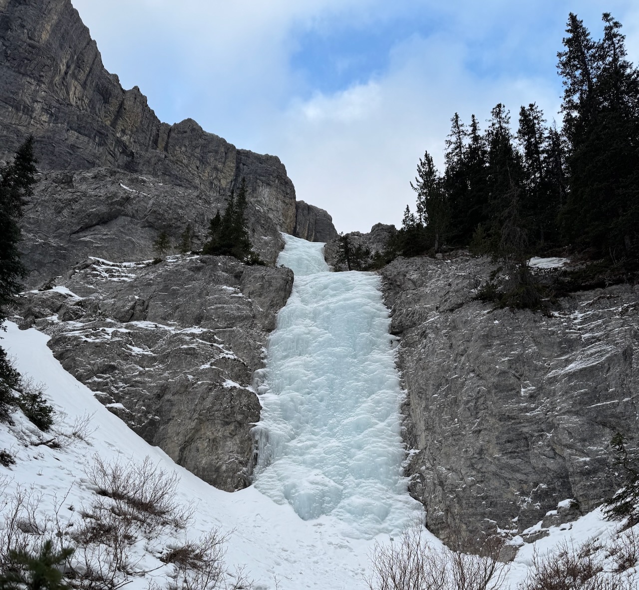
The trail headed up to the left. We went a short distance up the hill and found this beautiful piece of ice.
The Climb – Not The Joker
This did not look like the WI2 ice I was expecting but I was excited to get on and lead it.


My plan was to use up the full length of our 60-meter double ropes. I thought that then Dan could lead another 60 meters. The last 10 meters would be my lead and then we’d be in good shape to walk up to The Joker.
This bottom section turned out to be harder than it looked. I was expecting WI2 like Sinatra Falls, which we climbed in December, or Chantilly Falls, which we climbed last year. This was much harder.
I found it even harder than Step Right Up, a WI3 I had led a couple of days before this. Part of the challenge was that this ice was smooth and glassy with very few pre-existing pick marks or foot steps. Not like Step Right Up or Blue Cheese, which get climbed so often.

I ran the rope full length and then built an anchor from screws to bring Dan up.
Dan led above here and the ice disappeared after about 30 meters.
At that point, we decided to call it a day and turn back. We built a V-thread and rappelled.
The Descent
As I rappelled, I noticed a couple of pieces of cordellette around a tree on the right side. You’ll see it if you zoom in to the photo.
This is above the first long steep step and before the second, smaller steep step.

Chain Discovery
When we got back to the bottom of the ice, Dan took some time to explore in the forest on the right side.

I think I was taking a while to take off gear, enjoy some soup and pack up.
As he traversed along the bottom of the cliff to the right, he found this:
He called me up to look at this chain hanging down a steep section of the cliff. It was attached to a tree at the top.
Curiouser and curiouser…

As we hiked back to the van, we had so many questions from the day. Why was the chain there? Was it a “walk around”, to avoid the ice we had climbed? Would going up the chain make it quicker and easier to access The Joker?
What had we climbed? It was definitely Not The Joker. Was this the approach ice I’d read about? We found 90 meters of ice with a big WI3 section. Not at all the 130 meters of WI2 we were expecting.
Where did the other ice go, the ice in the first canyon we passed? Would it take us to another climb? I suspected it led to Hidden Dragon, a WI4 below The Joker and other climbs in the bowl above but I wasn’t sure. If we climbed it, was Hidden Dragon right above?
We were so curious, we decided to return two days later. We would find Hidden Dragon and climb it. Read about it in my next post, Hidden Dragon.

Leave a Reply