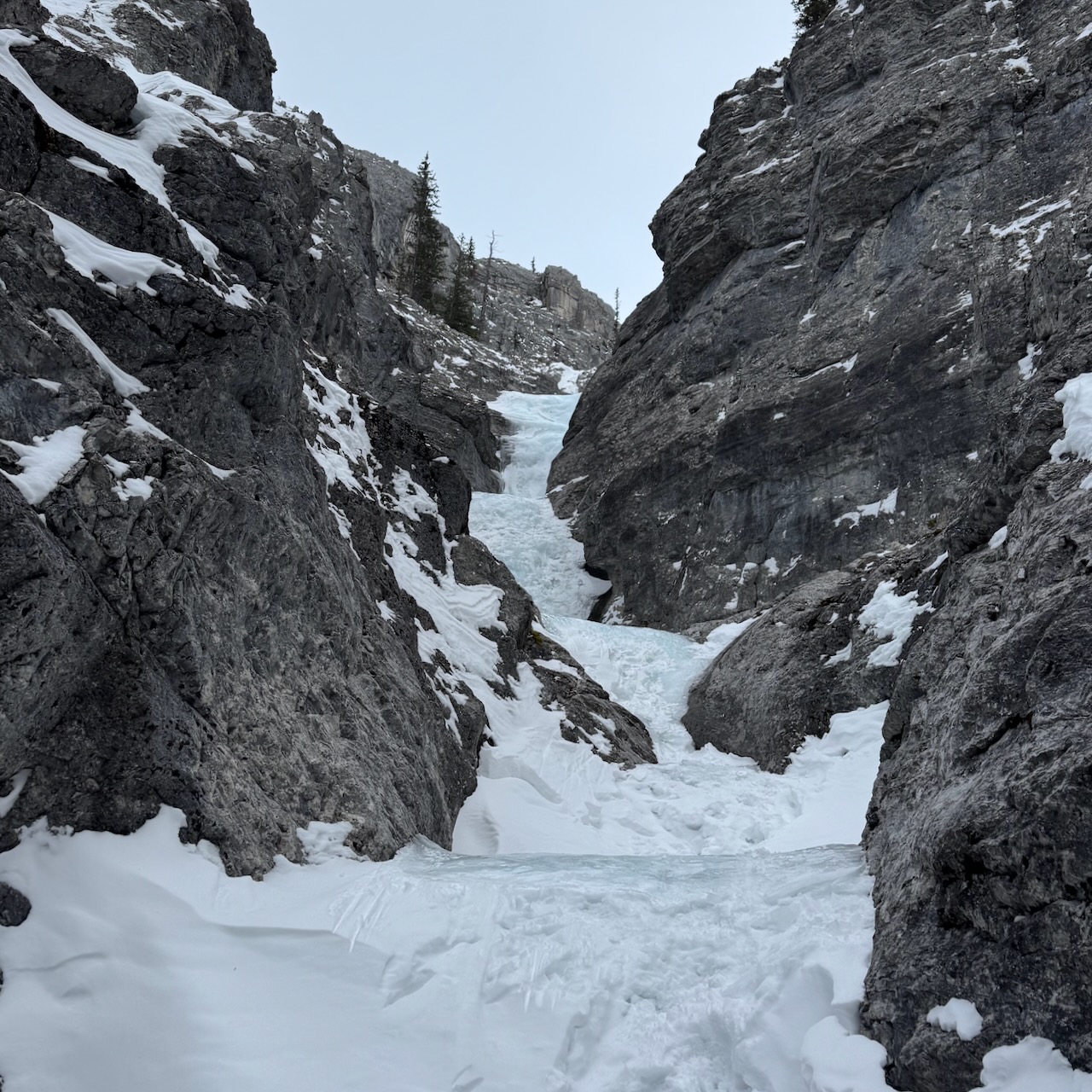
This House of Sky is a classic moderate ice climb in the Ghost Public Land Use Zone. It follows a canyon carved into a hillside. The route takes you across ice and snow, through narrow gorges and up blue ice pitches strung together like gems on a necklace.

We loved this climb and felt it was a great adventure, exploring and discovering the cool features of the canyon. We enjoyed deciding when to solo and when to climb on belay. There were numerous bolted anchor points, clearly marked with flagging tape (photo in Climb section below). The “walk-off” descent was well marked and included some fixed lines in steep sections. Overall, it was a great day out.
We climbed it on December 30, 2025 along with at least four other parties. Unlike most of the ice climbs I’ve done, This House of Sky can accommodate multiple parties. The ice pitches are separated enough that climbers do not rain ice down on those climbing below.
When we were there, a couple of the other parties soloed the entire route. One of the other parties pitched out a few sections and the other party, like us, pitched out more sections. Everybody was very willing to wait, give others space and let others pass where it made sense. We ended up passing a group of three and then letting two groups of two pass us. It made sense that people who were moving more quickly and able to solo most or all of the route, should pass those of us pitching out more sections, moving at a more leisurely pace.
Beta:
- WI3
- 10 pitches, but some may be combined or soloed, depending on your comfort
- large flat areas separate most pitches
- quick approach to the first ice pitch
- bolted anchor points at the top of all steep sections
- descent: walk off is preferred but bolted anchor points are set up for rappels
- one rope is sufficient
The Drive
The drive into the Ghost can be an adventure in itself. The first time I went there, I was with a mountain guide who knew the area well. Lucky me. If you’ve never been and you’re not sure where to go, I offer some suggestions below. Note that typically a truck, Jeep or other vehicle set up for off-road driving is needed to get to the climbs here.
- Open your maps app (such as Google Maps) and type in “Trappers Hill Lodges and Campground”. The directions will get you onto the TransAlta Road. Once you’re at the Trappers Hill Lodges, continue along the road. It soon begins to roll up and down some steep hills and then finally down the Big Hill to the river. There you leave established roads and follow rough tracks up the river. When we were there, we had to drive through the river three times.
- There is also a map showing the drive from Highway 1A to Highway 40, then down the TransAlta Road (past the Trappers Hill Lodges) to the river and on to some of the popular ice climbs in the Ghost including This House of Sky (labeled as “House of Sky” on the map). Find it here.
- The app “Ice Climbing in Western Canada” had a description of the route with a “navigate” button that will take you there. Learn more about the app here.
- I added our driving route to the map below from the GaiaGPS app. The yellow line is the drive from the TransAlta Road. I marked the Big Hill on the map. The purple line is our route on This House of Sky.

Below is a close up of the purple line, our route on This House of Sky. The double-dashed line labeled “Ghost River Trail” is the driving track along the river. There is a pull-out at the start of This House of Sky with lots of room for parking.

The Ghost River Trail drive has a lot of marker signs with numbers on them like this one with number 31. Just before the parking for This House of Sky, there is a marker sign with the number 44 on it.

The Climb
From the parking area, walk up the right side of a creek bed. There is an orange ribbon tied to the tree on the right in the photo.


This photo shows where the descent trail comes down from the right. It is marked with a couple of orange ribbons.
The approach continues up the creek bed.
Soon you reach a place where the creek splits. Stay right to enter the canyon for This House of Sky.


The trail heads around to the right.
And enters the canyon. Soon you start the climb and hike up the mountainside, exploring the features of the canyon.

Shortly you arrive at the first ice pitch. It’s a quick walk up to the first pitch of ice. When we were there, the first pitch was one of the two steepest pitches of the day. We decided to belay. Unfortunately, I did not get a photo of it.

The next ice pitch was less steep.
At the top, there is a walking section.
We enjoyed hiking up the creek, seeing how the water had carved the rock.


Here, the canyon widens and the walk continues.
This was the first bolted anchor station we came to. The bolts are set up for rappels and they are all marked with red tape which makes them very easy to find.


Further up, there is more walking through the canyon.
The bottom half of the route has more walking than the top half.


The route continues around the corner, through a narrow cleft in the canyon.
An interesting chockstone rests in the canyon here. We soloed the ice on the left.


Another walking section.
Here the route goes around another corner into a narrow part of the canyon.


Time to climb.
We soloed this ice.


More fun ice.
Leads to more walking


Leads to more fun ice.
We decided to belay this one but other soloed it.


At the top, some rolling ice.
Another pitch of ice. We were roped up but didn’t need to place any screws.

Unfortunately, I did not take a photo of the last pitch. It was a moderate, tiered pitch that ended at the top of the canyon.

Just over the top on the right side, the final set of bolts is marked with a cairn as well as the usual red ribbon. If you zoom in, you’ll see another cairn further back. It marks the start of the descent trail.
At the top, there is a large plateau. The creek comes down the slope in the distance creating more striking blue ice pitches.

The upper pitches looked incredible! But we didn’t go check them out. Maybe next time. For us, it was time to descend.

The Descent
At the top, we sat and took off our gear, ate some lunch, and got everything stowed in our packs. We turned right and hiked uphill, past the cairn.


Just inside the trees, a chair-and-table memorial is situated to take in the views.
The trail continues past the memorial. It is well marked with red squares on trees and ribbons tied to branches.


The trail heads through burned trees toward the top of the next hill.
Frequent trail markers made sure we stayed on track.


This is the first of many steep sections.
I’m not sure how long ago this forest burned but the trees were still covered with soot when we were there. By the time I got back to the parking area, my gloves and sleeves were black from holding onto trees on the lower, steeper sections.
A first view down to the river. The ice climb “The Good, The Bad and The Ugly”, aka GBU, is visible along the river below.


Here is the first fixed line, a cordellette with knots tied along it. It makes a slippery down-climb section easier.
Further down are more fixed lines.


Closer to the junction with the approach trail, the descent is steep and unrelenting.
The loose snow made it a lot easier. I would have liked micro spikes if the trail was hard packed and slippery.
It was easy to see why this route is a classic. Two of the parties we met on the route had done it many times before and seemed to be thoroughly enjoying climbing it again. Some climbers do this route every year. I can certainly see why.

Leave a Reply