Albatross is one of several ice climbs in the Valley of the Birds, located in the Ghost Public Land Use Zone in an area known as the North Ghost. When I started researching this climb, I mistakenly imagined the Valley of the Birds as a wide valley with a forested floor and tall distant walls.

The valley is actually a gorge with steep walls carved by the creek that runs through it.
We hiked and climbed up the gorge on January 1, 2026. The creek was nicely frozen with no open pools.
We chose to climb Albatross because we wanted to explore the valley and do a moderate climb. Albatross is near the top of the valley.
Beta:
- WI3
- 3 pitches
- approach through the Valley of the Birds
- bolted anchor points at the top of all steep sections in the Valley
- tree anchor and bolted anchor for the first two pitches of Albatross
- descent: rappel the route, downclimb and rappel the Valley of the Birds approach
- we used two 60 meter ropes which made the rappel off Albatross much easier
The Drive
The drive into the Ghost can be an adventure in itself. The first time I went there, I was with a mountain guide who knew the area well. Lucky me. If you’ve never been and you’re not sure where to go, I offer some suggestions below. Note that typically a truck, Jeep or other vehicle set up for off-road driving is needed to get to the climbs here. When we went to Valley of the Birds, we drove through the river three times on our way to the parking.
- Open your maps app (such as Google Maps) and type in “Trappers Hill Lodges and Campground”. The directions will get you onto the TransAlta Road. Once you’re at the Trappers Hill Lodges, continue along the road. It soon begins to roll up and down some steep hills and then finally down the Big Hill to the river. There you leave established roads, turn right, and follow rough tracks up the river.
- There is a map showing the drive from Highway 1A to Highway 40, then down the TransAlta Road (past the Trappers Hill Lodges) to the river and on to some of the popular ice climbs in the Ghost. The Valley of the Birds is marked on the map as VOTB. Find it here.
- The app “Ice Climbing in Western Canada” has a description of the route with a “navigate” button that will take you there. Learn more about the app here.
- Below is a map from my GaiaGPS app. The dark purple line is our hike/climb up the Valley of the Birds and Albatross. I marked the TransAlta Road and The Big Hill where you drive down to the river. You then drive up the riverbed, seeking the path of least resistance. When you arrive at a wide curtain of steep ice called The Good, The Bad and The Ugly (GBU), you continue to drive, choosing a track that is close to the river for another few hundred meters until you see the entrance to the Valley of the Birds.

The Valley of the Birds

We drove past the GBU and parked near the river.
We found the ice that marked the narrow entrance to the gorge across the river.


We looked for the best way to cross the river and found a log across the water. The log looked icy and the water was deep under it so we decided to look for a better way across.
Downstream about 50 meters, the river was wider and the water shallower. We managed to cross here without getting water in our boots.


The first pitch of ice was not super steep but we decided to belay here. I’m guessing most folks solo this. We wanted a more gentle warm up to the day.
At the top, Dan found a bolted anchor station set up for rappel. We used it rappel when we came down at the end of the day.


We continued up easier ice steps in the gorge. I think we soloed everything after that first bit of ice.
In many places, logs and branches were lodged in the gorge. At times, we got creative with the tools to get up and over them.


Many of the steeper ice steps had pick holes and foot holds carved into the ice, making it easier to solo. It felt like connect-the-dots at times, going from one pre-made hold to the next.
It was fun to explore the gorge and see what was around the next corner, enjoying the easy movement with tools and crampons without having to rope up.


we continued across flat spots
and up small steps


to a long hiking section
to another small step.


We noticed these anchor/rappel stations frequently. I think we saw five of them altogether on the way to Albatross.
It was a lot of fun moving up these steps, exploring the gorge.


There are bolts everywhere you might need them. We ended up doing 2 rappels on our way down the gorge at the end of the day.
The ice steps were in good enough shape that we could down-climb the rest.


A trail through a wider section of the gorge. Exploration continues.
Yellow Bird
Up ahead, we get our first glimpse of the approach ice for Yellow Bird.


Here we see an ice step with a log running up it, then the approach ice and then Yellow Bird, a single pitch WI4, above on the right.
Yellow Bird looks enticing.


First, we climb the ice step with the log.
It was steeper than it looked from a distance.


A closer view of the approach ice.
It looks like a WI3 to me. Could be wrong. We didn’t climb it.


The path through the gorge continues past the Yellow Bird approach ice. We declined the side trip up Yellow Bird and continued toward Albatross.
Seagull
An interesting section of narrower gorge walls carved smooth by the water.


A short hike along the creek bed
And the approach for Seagull comes into view.


This one is on the opposite side of the gorge from Yellow Bird and it seems to get more sun. Here it looks quite sun-affected. We didn’t climb it.
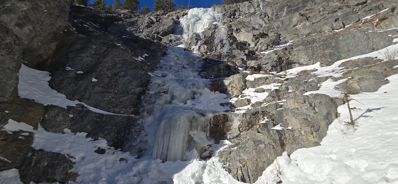
Albatross
We hiked on for another 5 or 10 minutes


And came to the approach ice for Albatross. You can’t see it in the photo but the gorge continues around to the right and there is an ice step leading toward The Eagle.
This shows the approach ice with the first pitch beyond.

There are bolts on the right side of the base of the first pitch, circled in the photo below. I anchored myself here to belay Dan as he led the first pitch. After the climb, we used these bolts to rappel back down the approach ice to the main trail.

In the photo below, I circled the tree anchor for the top of the first pitch. This is where we should have ended the first pitch. There is cordellette around the bottom of this tree on the left as you come over the top of the first pitch. Our rope is coming down the short, second pitch (I took this photo when I was rappelling). The third pitch starts off to the right above.


Dan pressed on to two bolts at the base of the third pitch, combining pitches 1 and 2. I had to climb up a little at the bottom of the first pitch to give him enough rope to put me on belay. All good, we were used to a bit of soloing by then.
Here he is at the two bolt anchor. This would be the starting point for the third pitch, visible on the right.
The third pitch was soaking up the sun when we arrived. We thought we wouldn’t be able to get any quality screw placements here so we bailed. Our 60 meter ropes just reached the ground at the bottom of the first pitch with our full weight hanging on them. Talk about a rope stretcher!


On the way down, I paused to take a photo of The Eagle. This stunning climb is rated WI5 and above our ability to lead. At least for now.
The Valley of the Birds was a beautiful day of fun exploration and climbing. We will return when the ice has had a chance to freeze up a bit and hopefully climb Yellow Bird and Seagull. When we do, I will add posts to this website.
If you want to get an email when new I add new climbs, subscribe here.

Leave a Reply