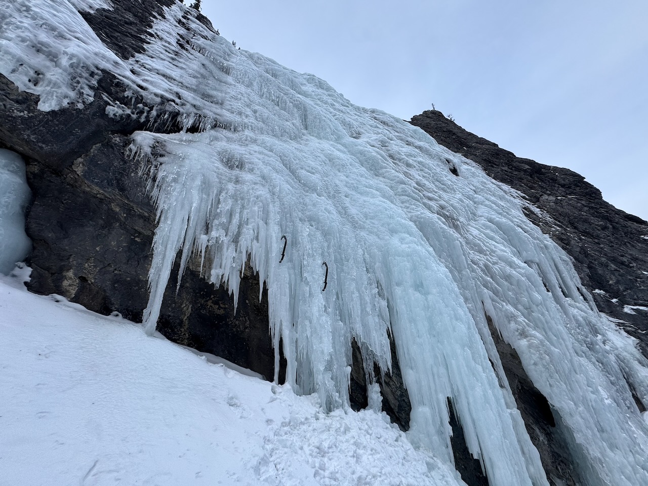
Lovely Parting Gifts is a WI3 in the David Thompson area. It is very close to the popular WI4 – End of the Line.
Dan and I hiked up the canyon to look for these climbs a few years ago. There had been a recent heavy snowfall and we slogged up the creek in the deep snow, finding no sign of a trail or path except for the occasional fixed line attached to the rock wall. After post-holing up the canyon for a couple of hours, we turned around. We didn’t see the climbs that day but vowed to return and find them.
On February 3, 2026, we went back to climb Lovely Parting Gifts (the WI3) and check out End of the Line (the WI4). This time, we were successful.
Beta:
- WI3
- 65 – 70 meters of ice
- no anchors, be prepared to make a v-thread
- descent: rappel from tree and/or v-threads
- we brought our 70 meter rope and really wished we had our 2 60’s when it was time to rappel
Access
From the Icefields Parkway, turn onto the David Thompson Highway, Highway 11. Drive about 35 km and look for a creek bed on the left. Pull a u-turn and park just off the road near the creek bed.

The red line on the map above is our route to the climb. The creek comes down the drainage between Elliot Peak and Mount Ernest Ross (not on the map).

We parked just off the road, on the left side of the creek near a big clearing.
The Approach
We hiked across the road-side clearing toward the creek.

There was a trail in the trees at the edge of the clearing, leading down to the creek.
I was relieved to see a well-worn path in the snow going up the creek. I hoped that this time, we would be able to follow a trail to the climbs.


Looking back at the road, there is a big culvert where the creek runs underneath it.
We started our hike up the creek, heading toward the rock wall ahead.


The creek bed continues to the rock wall.
As we approached the rock wall, we saw bolts in the rock on the left. We stopped to scope out the rock climbing routes. They looked like a lot of fun. Maybe we’ll be back in the summer.
Here we turned left to continue up the creek. We had come nearly 1 km and up about 100 meters of elevation gain.


Around the corner, we could see the start of the canyon.
On this day, the creek was fully frozen and we didn’t need to worry about falling in.
When we were here a few years ago, I stepped through the ice and into the creek. With all the snow packing into the hole, my foot was stuck pretty tight down there. Dan helped me pull it out and we carried on. It was a good thing my laces were done up tight or I might have lost a boot down there!
The Canyon
The narrow canyon with high rocks walls towering above was amazing to explore. This is such a great hike and would be a great day out, even if there wasn’t any ice to climb.


Up ahead, we saw the first fixed line.
The fixed line made this section pretty easy and allowed us to keep our tools on our packs.
In addition to the fixed line, there were via-ferrata style foot holds. We didn’t need crampons to climb this.


It was a fun start to the canyon hike.
Ahead we saw the first ice step. There was a fixed line up the right side but it looked more straightforward to go up the middle.
We put on crampons and harnesses here and took out our tools.


A quick free solo up the step and…
and the path through the narrow canyon continued.


Such a cool place.
There were occasional obstacles – big boulders or fallen logs.


The well-worn path continued through the canyon.
Here the canyon widened a bit.


Another fixed line helped us up a step.
We came to a fork in the canyon. This ice step was on the left.
We noticed some fixed line above and realized that this is the way to the ice. It was 1.75 km from the road and an elevation gain of 230 meters.


This is the view up the right fork. Although there is a path going up there, we were pretty sure the step on the left was the way to the ice climbs.
There is partly formed ice up the right fork. If you see this, you’ve come too far and you need to turn around and go back to the ice step.


A free solo of the step (the highest so far) brought us up to a path with more fixed line.
The fixed line was invaluable here, helping us get around a pool of open water.


Past the pool, we followed the worn path.
The path went into another narrow section of canyon.


Ahead an interesting rock formation on the cliff wall looks like a giant triangle.
We continued up the narrow canyon.


There were some steep hills in the canyon during the final stretch to the ice.
At last, we caught our first glimpse of the ice ahead.

The Climb

As we got closer, we knew this must be Lovely Parting Gifts.
It hung down the side of the canyon wall. The canyon carried on past it.
We had hiked about 2.8 km and come up about 285 meters from the road.
We could see that the bottom part was quite steep.


The bottom part of the climb was ice hanging straight down over an open area where the rock behind cut back. It looked a bit thin and intimidating.
We found a spot on the left where there would be enough ice to climb and the steep section was not too high.
It was my turn to lead and I scouted out a good line on the left side of the climb.

I got going on lead and was a bit intimidated by the steepness. I pushed on and quickly came to a less steep section where the ice eased back and I could put most of my weight on my feet.
The pitch was long with not a lot of opportunity to rest and I was tired as I came toward the top of the ice. Dan call up that I had only 5 meters of rope left. I looked at the rock, hoping to see some bolts. The Ice Climbing app we often use said that there is a single bolt on the left at the top but I couldn’t find it. I carried on and built an ice screw anchor to bring Dan up.
The Descent

In this photo of the top of the climb, the pink arrow points to where I ended up building the ice screw anchor. The blue circle is where there is cordelette around a tree for rappelling.
When Dan came up to my anchor, he carried on to the tree with the cordelette. He then brought me over.


Our rappel from the tree took us down the right side of the ice. Again, I searched for bolts in the rock on the right as I rappelled.
Finding none, I built an ice screw anchor. Dan then came down and we built a v-thread for a second rappel.
I don’t know if our 2 sixty-meter ropes would have reached the ground from the tree or not but the next time we climb this, we’ll bring the sixties and give it a try.
Dan also led the line and he stopped to rappel at an existing v-thread partway up. By then we knew that the best climbing was in the lower half and the top, less steep part was not worth climbing if it meant two rappels to get down.
Back on the ground, we left our packs and hiked up to look for End of the Line.


It didn’t take long to find it. This ice is at the end of the canyon and the name seems appropriate.
We stood looking at it, knowing that the next time we are here, it will be to climb this fun looking WI4.
As we hiked back toward Lovely Parting Gifts, I took another photo of it.
It was a fun climb and an interesting experience building a v-thread to rappel. We haven’t done that much but it is an essential skill that we’ve practiced a lot. It was good to use it.

I’m looking forward to going for End of the Line on our next climbing trip to Lake Louise. When we do, I’ll write a trip report and post it here. If you want to get an email letting you know when I add a new trip report, scroll down to subscribe.

Leave a Reply