This summit has been on our radar for a long time. It is one of the peaks that is visible from Canmore, Alberta. Both Dan and I have spent a lot of time in Canmore and we’ve enjoyed many days there exploring the surrounding mountains. But neither of us had climbed Bald Eagle Peak.
We did this scramble on the Saturday of a long weekend (June 29, 2024) and we met only one other party.
We followed the route in the AllTrails app. It starts on some of the mountain bike trails that traverse the base of the mountain and then it turns sharply up to gain elevation on steep slopes. After that, we used the description in Alan Kane’s book “Scrambles in the Canadian Rockies” to find our way to the summit. Details and photos are below in the Trip Report.

Beta:
- This is an out-and-back route, descending the summit the same way as the ascent. Keep in mind as you climb that you will need to reverse your moves on the way down. Do not proceed if, at any point you are not comfortable with the idea of downclimbing the section ahead.
- Parking: Off Harvie Heights Road there is a small parking area near the base of the mountain.
- Elevation gain: 1,142 meters
- Distance: 10.6 km total out and back
- Difficulty: Very steep hiking up dirt trail and loose rocks followed by full on climbing moves on sticky slab and good holds.
- Gear: we should have brought helmets. Traversing below the summit block, there is a real danger of rock fall from above.
Permit Required
A Kananaskis Conservation Pass is required to park at the trailhead.
Helpful Apps
- AllTrails – Anû Kathâ Îpa (Bald Eagle Peak)
- FATMAP
Websites
Interesting to note that each of these summiters took a slightly different approach route for the lower forest section.
Books
- Scrambles In the Canadian Rockies by Alan Kane
Trip Report
I snapped this photo of Bald Eagle Peak as we drove through Canmore from Calgary. We debated whether the tower-like summit block is more like the head of a bald eagle or an eagle’s nest high on a tree-top.

There is a lot of snow on the mountain to the right and a little dusting up high on Bald Eagle. We hoped the ascent route would be snow-free and dry.
The approach hike starts on mountain bike trails. At this junction, with the “Meander Trail”, we turned left.
Then we turned right onto a narrower, fainter trail that would take us up to the “Montane Traverse” higher on the mountain.


The narrower trail is still well-defined and easy to follow.
We followed this trail to where it came out at the creek.
The map on AllTrails showed the trail crossing the creek and heading up through the trees on the other side. But it was easy to hike up the right side of the creek to where the trail re-crossed and entered the forest.
The creek was flowing nice and very pleasant to walk beside.


Further up the creek, we found the trail on the AllTrails map heading back into the forest.
We were now on the Montane Traverse trail. We followed it until we came to a junction.
Here the trail up to Bald Eagle Peak really begins. We turned left onto the fainter, narrower trail and immediately began a steep uphill hike that just kept going up.
I think sometimes scramblers and climbers forget to put switchbacks in their trails.


It can be hard to capture the steepness of trails in photos.
The trail continues up through the trees. At times, it forks into multiple paths seeking the most solid route up the loose rocks.
There were a few of these high slabby walls on the way up through the trees. The trail goes around on the left side each time.


Trails wind between slabs and around trees. At this point, as long as you’re going up, you’re going the right way.
As we gained more elevation, the trees started to thin out.


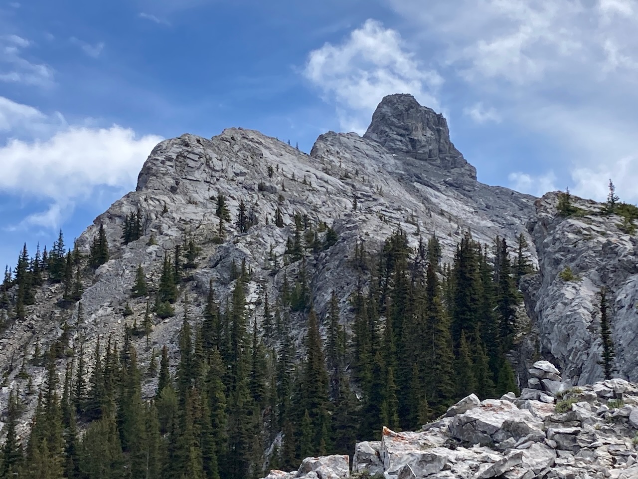
At last, near tree line, we stopped for a break and studied the route ahead.
Kane says to stay on top of the ridge as much as possible. From this perspective, it looked to me like getting up on the narrow shark fin of a ridge would require some serious climbing moves. I was apprehensive.
There was a party of two ahead of us on the summit route and as we studied the ridge, we saw one of them standing on top of the first lump.
You can see him in the photo on the left skyline. Seeing a person up there helped calm my nerves.

Scrambling Begins

Here Dan decided to fold up his trekking pole and slide it between his back and the backpack.
Two hands were needed here! This was one of the first climbing sections.
Here is another look at the same section. There are lots of good footholds and handholds but it seemed like a long climb to me without a rope.
Fortunately, the climbing was easier than I expected and I was up in no time.


Here Dan starts up another scrambling section.
There was also some down-climbing on the way to the summit, as we stuck to the top of the undulating ridge.
There did appear to be trails from time to time that stayed low around the rocky ridge-top but I think these were game trails only useful for mountain sheep. I think Kane’s advice to stay on top of the ridge put us on the best route.
Yet another scrambling section and we were starting to get good at this. I was feeling a lot more comfortable.

The Summit Block

And then we arrived at the base of the huge summit block. I do think it looks more like a bald eagle head than a nest.
Using the description in the Kane book, we figured out the way to get up this stoney monolith is on the left side. We were to scramble up the trough / left facing corner.
I have marked it with an arrow in the photo below.

At first, this seemed like a crazy plan to me. From a distance, it looked steep and high.
Also, as you can see, there was a bit of snow left when we were there. Unfortunately, there was water running down the trough in the corner. This made me feel even more intimidated.
But as we got closer, the trough looked a lot less steep. And it turned out, the slab in the trough was prickly and quite sticky in many places so it wasn’t as slippery as I feared. There were some good handholds in the corner and it ended up being easier than it looked. But I would say this was the crux of the route.
At the top of the trough, we traversed a bit more around to the back. There we found another less-steep trough and scrambled up it to the summit.
The Summit
At the top we found a sword (Excalibur?) stuck in a crack in the rock. Dan is about to pull it out and claim the throne.


Here I am opening the summit register which is in a black plastic tube.
I signed our usual “Dangela” in the little notebook inside.
We took our time on the down-climb. It wasn’t tricky but a mistake could have been disastrous.
You can see in the photo that the right side of the ridge has a big drop-off. Not a place to trip and fall!

As I scrambled up and down-climbed the ridge and the summit block, I was sure happy I had some rock climbing experience. Being able to find good handholds and footholds and knowing how to use them made this scramble a lot more straightforward for me.

Rating / Grade
This was the most challenging scramble Dan and I have done so far. I thought it was rated F3 in the alpine rating scale but I could be wrong about that.
Last year, Dan and I climbed routes on Mount Rundle, Grotto Mountain and Mount Sparrowhawk that are rated F2 (if you click the names, my Trip Reports will open in new tabs). Bald Eagle was a lot more challenging. Definitely harder than F2.
We are planning to try Mount Chester next and then Mount Hood which are F3’s. I am curious to find out how they compare with Bald Eagle. If you want to be notified when I publish those and other Trip Reports, subscribe to this website here:
Descent
I did manage to make one screw-up on this trip. I took a wrong turn on the way down, assuming it would be easy to find the trail we hiked on the way up. However, I was too far to the right (skier’s right) as we descended and I led us off onto a trail that dropped steeply into the creek.

By that time, the creek was pretty full with the afternoon run-off and it was impossible to hike down the creek. We had to go back up the bank and bushwhack through the forest to find the correct trail.
Not a bad screw-up and it didn’t cost us too much extra time but it would have been better to avoid this extra hiking and route-finding on the way out.
That’s the second time this year I’ve taken the wrong trail at the end of the day on our way back to the parking lot. The first time was on our Keelhaul Wall multi-pitch climb. Seems I haven’t learned my lesson! I’ll be sure to pay more attention on our way out next time. I’d hate to make such easily avoidable mistakes on a really big day.
If you’ve climbed Bald Eagle Peak, please share your thoughts on the experience in the Comments box below. If you are planning to climb it and you would like more information, contact me using the Contact page.

Reach the peak!
Read about our other summits:
Leave a Reply