We spent two days in January 2025, ice climbing on Orient Point, a mountain in the Ghost River Wilderness Area north of Canmore and west of Cochrane. The first day, we enjoyed finding and exploring the climbing area. We had intended to climb The Joker but we climbed a pitch of WI3 that was Not The Joker. The second day, we explored a canyon filled with ice, up to WI2. It led eventually to Hidden Dragon, a wide curtain of WI4 ice. Dan did his first WI4 lead here.
During our descent, we found our way to the top of the chain we saw on the first day. We used it to get back down to the approach trail. That way, we were able to avoid downclimbing and rappelling the canyon ice.
Beta:
- a wide curtain about 30 meters high
- WI4
- the approach hike is about 1.5 km from the parking on the cutline
- then there is approach ice, a long canyon full of ice up to WI2, which can be avoided with a walk around – described below under The Descent.
- we didn’t find any established anchors or bolts
- descent: we rappeled Hidden Dragon from v-threads and then walked through the forest around the approach ice canyon
The Access and Approach sections are the same as the post for our first day in the Ghost when we climbed Not The Joker.
Access
The Ghost is notorious for the challenging access. There is rough driving on dirt road and then off-road driving that usually requires a truck or other four wheel drive vehicle. Conditions vary greatly with snow levels and temperatures.
On the map below, the bright orange line is our hike in. The white bars are gravel roads.
To reach this area, starting on Highway 1A, drive to Highway 40, Forestry Trunk Road. Take this road through the villages of Benchlands and Waiparous. Continue until you see signs for Richards Road. Take the left turn immediately after Richards Road.
Here you leave pavement and get acquainted with gravel, potholes and washboard road. Watch for rocks, firewood and other debris on this road. Drive up and down hills, past primitive campsites, until you come to “The Big Hill” that drops down to the river bed.
When we were there, there was very little snow and no water in the river bed. We went straight across and found a gravel “road”. It was basically two rutted tire tracks following the river bed on the other side.
Map to the Climbs
On the map below, the gravel road is the white bar that comes from the right (east) side of the map, past Trappers Hill Lodges. Follow the road west to the T intersection at the river. Here take the rutted tracks left (south) toward Orient Point. The tracks take you along the west side of the river (dry when we were there). Here the mountain is guarded by a steep hillside that you could not drive up. Continue south. When you are closer to the climbs, look for a cutline that leaves the river, and drives left to right up across the hill side, up into the forest.


If your vehicle can manage it, drive up the cutline. This photo is looking back down the cutline. You can see it continue straight across the valley on the other side of the river.
Follow the cutline straight toward the climbs ignoring turn-offs unless they are drive arounds for impassable sections of road.
The main parking is a pull-off on the right. We drove a little further past the main parking and parked on the left in a small pull out.
From here, we hiked up the cutline.

The Approach
The Approach starts up the cutline and follows it, first gently uphill and then it gets steeper.
Cutlines don’t switch back, they just go straight up hill.


Watch for the trail that goes into the trees on the left, before the top of the cutline.
It is marked with orange flagging tape tied to a tree.
And the cordellette tied to a tree at the start of the trail makes it obvious that this is a climber’s trail.


The trail takes a more gentle uphill line, a relief from the steepness of the cutline.
It traverses around the hillside toward the drainage below the ice climbs.

As you come around the hillside, you start to get views of the ice climbs in the bowl.

Hidden Dragon is not visible in the photo above. It is, of course, hidden somewhere behind the dark patch of trees in the distance on the apron below the bowl with the big ice climbs.

Eventually the trail crosses the creek and continues up the left side.
The lack of snow when we were there made it easy to see the pretty blue ice on the creek.


A few minutes later, we saw a pretty blue column.
This vertical ice was our first objective on this day. We were keen to climb it and see what was above.
Our first day in the Ghost, we walked past this canyon but vowed to return.
Now we were back and ready to climb it. It was Dan’s turn to lead.
It ended up being a fairly straightforward WI2.


Above the WI2 pitch, the ice continued. I led up a couple of small steps, just putting in a single screw. We could have simul-climbed here.
This is the upper part of the canyon ice. We free soloed these short, moderate steps.
At the top, we continued to hike along the creek which turned left. Around the corner we got our first views of Hidden Dragon.

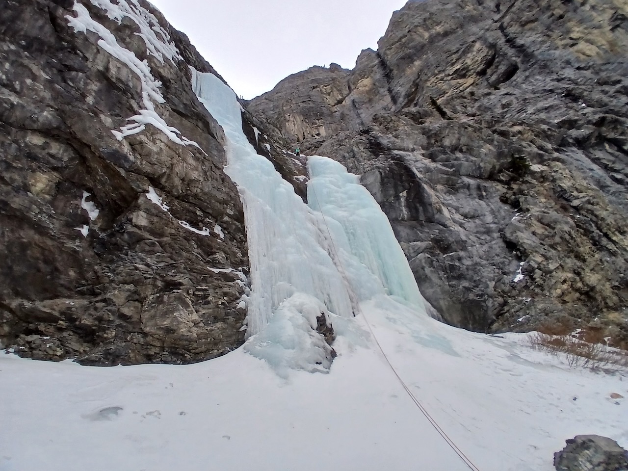
The Climb – Hidden Dragon

Coming up to Hidden Dragon on the headwall.
The ice in the upper left is The Joker.
A closer look at Hidden Dragon as we walked up.

Dan getting ready to start his lead. This photo does not capture the height of the ice. It looks smaller here.


This photo gives a better idea of how much ice there is.
I am standing at the top, cleaning the anchor and preparing to rappel.
Here is a closer view of the ice we climbed.
I didn’t see any bolts up there. There was an old v-thread frozen in the ice. We added a new v-thread and backed it up through the old v-thread which I partially excavated.

For my non-climber readers, a V-thread involves drilling a channel through the ice with a long ice screw. The channel forms the shape of a v. A piece of cordellette is then threaded through the channel and tied off into a loop. The rope is threaded through the cordellette for a rappel. When all climbers are on the ground, the rope can be pulled down. The cordellette stays behind.
The Descent
We hiked back down the creek to the WI2 canyon ice, planning to rappel from v-threads and down climb where we felt comfortable.
We got to the top of the first ice step. It looked intimidating and I started to think a rappel would be needed. There was an ancient piece of cordellette tied to a fallen log across the creek.
Dan noticed a trail going into the forest on the right side of the creek (facing down). We decided to check it out.
We hiked through the woods, traversing steep hillside at times, above the WI2 canyon ice.
Eventually, we found this:
It’s the top of the chain we found the first time we were here. A trail led down steep steps on the hillside to get to it.
We had to downclimb a bit on the way, but it was quicker than rappelling. We could leave our ropes in our backpacks.


This is looking back up the slope we came down to find the chain.
This photo shows how the chain is attached to the tree. It seemed really solid.


Dan starts down the chain.
We used the chain to descend this section of rock.
After that, we were walking back to the trail.

This was a very satisfying day. We explored a canyon, which I love to do. The ice wasn’t super challenging but I love climbing up and seeing what’s around the next corner or at the top of the next step.
We climbed a really cool WI4, Hidden Dragon. There is so much to do there, we want to go back and climb some more lines. Now that we know how going up the chain leads to a trail that takes us to the climb, we can head directly up there and skip the canyon ice.
It’s also really cool to get to know an area. There’s a lot left for us there. Another day or two at Hidden Dragon and eventually we might even go climb The Joker which is what brought us out there in the first place.

Leave a Reply